

Unknown Tibet. The Great Lakes and Kailas Mountain
At the beginning of September 2014, a unique expedition of Russian travelers to the area of Great Lakes of Tibet and to Kailas, the most sacred mountain in Asia was completed. The expedition was led by one of the famous explorers of Tiber Mr. Sergey Balalaev. The first part of the route coincided with the route of Tibetan part of the Central Asian Expedition (CAE) conducted by the Roerichs 86 years ago. The expedition was timed to 140th anniversary of Nicholas Roerich. The purpose of the expedition was to follow the route of CAE, to identify the places on the route, and to continue the study of this unique region of our planet, which still remains a blank spot to European explorers due to geographical and, especially, political limitations. This area is one of the most inaccessible territories on the globe.
Unfortunately, due to lack of time, even though the schedule of the expedition was very busy, these studies can be called preliminary; they will only outline future research. It should be noted that for many members this trip was also a pilgrimage, a spiritual journey, in the course of which a unique internal experience and knowledge was got.
 and the route of 2014 Russian expedition (blue line)") |
| The route of Central Asian Expedition (green line) and the route of 2014 Russian expedition (blue line) |
The route of this expedition was a circle, beginning and ending at the town of Zangmu with the length of 3000 km and included branches to the Everest base camp and Mount Kailas. There was more than 200 km of walking, under high-mountain conditions.
The expedition visited the following big lakes: Namtso, Serling, Kering, Dangra Yumtso, Teri Namtso (Tashi Namtso), La Nga (Rakshas Tal), Mapam Yumtso (Manasarovar), as well as a number of small lakes: Pangong, Taktse, Tangshung, Takyel.
The expedition members were amazed at a variety of ancient castles, temples, villages, stone pillars, tombs, caves, rock carvings and inscriptions, virtually unknown to Western travelers.
The expedition explored archeological monuments belonged to different epochs. Several large megalithic complexes were discovered on the northern shore of Lake Namtso and Tashi Namtso, on the southeastern shore of Lake Tangshung, on the northeastern shore of Lake Dangra. A huge multi-level megalithic complex near the town of Namru was especially impressive. Apparently, it has not yet been investigated previously. Given the facts that granite is eroded a lot and the stones are sitting deep in the ground, we can assume that these megalithic complexes date back to the Paleolithic Age.
 |
| Megalithic complex near the town of Namru |
A lot of round-shaped stone structures were discovered; they are likely to be of a later origin. They usually look like a circle with the diameter of 5-15 m having the entrance from the East, “the throne” in front of it and a central stone.
There are a lot of caves near every lake; these caves were used by practicing yogis for retreats from ancient times. The expedition found and documented cave paintings and inscriptions related to both the Buddhist and pre-Buddhist periods.
The Great Lakes of Tibet are located along the 30th parallel, more precisely between 30 and 32 degrees North Latitude, from Lake Namtso in the east to Lake Rakshas Tal in the west. The Great Lakes stretch for nearly one thousand kilometers across the Changthang Plateau. At the 30th parallel there are also many monuments of great civilizations: the pyramids of Giza, Jerusalem, Lhasa, Delhi, etc.
The Great Lakes initially were associated with the cult of the feminine principle, the Great Goddess that seems to be one of the most important factors in the heyday of ancient civilization of Shang Shung. Over time, this knowledge has been largely lost ... End of the Shang Shung era coincided with the beginning of the cycle of domination of the masculine principle ... But perhaps soon the cycle of honoring the Great Goddess will be reborn and it will have a big impact on many people...
Around 160 km to the north-west from Lhasa, the second largest lake in Changthang (approximately 2000 sq.km) is located – Namtso Lake (Heavenly Lake). It is believed that this lake is the soul of Tibetan people…
The expedition visited Cape Nying Do (Cape Heart) and found remains of a Pre-Buddhist village consisting of 12 houses and megalith sanctuaries.
 |
Almost in the middle of the northern coast of Namtso Lake a monastery (gompa) is located called Tamchok (Chief Horse). The most distinctive characteristics of this sacred place are two pyramidal stone formations similar to the "horse's ears". There is a natural passage with steps leading to the top of the "horse ear" in one of the formations. Unfortunately, the stairs for the last time were so badly damaged that it is difficult to use them. At a short distance from the stone formation remains of stone walls are clearly visible. Locals, drokpa (nomads), believe that in pre-Buddhist times Tamchok was a very sacred place and that the local ruins are the remains of a Bon monastery. Despite the small size of the structures gorgeous scenery gives the place the spirit of holiness.
 |  Mountain") |
| Two “ears” of the mythical Horse | The head of the mythical Horse aimed at the Tanggula (Tang Lang) Mountain |
 |
| Man-made stone stairway leading to the middle of the right “ear” |
Not far from this place, there are two stone formations resembling two elephants (or mammoths); what is especially interesting, from many angles.
 |
| Two stone mammoths – sacred guardians of these place |
At the northern coast of the sacred Namtso Lake there is a gorgeous element known as Tanglay Gyago - a natural archway, set on a rocky platform extending into the lake. They say that this formation is like an elephant, with which it has an extraordinary resemblance.
This elephant-like lime formation has a natural orifice with the height of 6 meters. This is so-called "the main gate of Thang Lang Mountain " - a place of immense geomantic force. If you walk through this natural archway, Thang Lang Mountain will be located right in the middle on the opposite side of the lake at a distance of 49 km. It is said that at this point the sacred lake and the mountain are united in cosmogonic union. Since ancient times this mystical place must has inspired reverence...
 |  |
| Natural archway, the main gate of Tang Lang Mountain | View to Tang Lang Mountain from the archway |
At the distance of 360 km to the west from Namtso, another lake, Dangra Yumtso Lake (Ocean turquoise lake), which reaches a length of about 80 km, is located. The expedition route ran through areas of Targo Mountain and Lake Dangra, which are sacred for the Bonpos. These areas are virtually never visited by foreigners. Such a unique combination of one of the largest lakes of Tibet with the splendor of the high snowy ridge makes this area one of the most spectacular places in the country.
Dangra Lake has much in common with Namtso Lake – both of them are lakes of Goddesses. According to Bon mythology, Dangra Giyalmo, benefactress of the area, manifestation of Mother Universe, lives in this lake. Dangra Giyalmo is the chief keeper of land fertility and livestock. She is the original Mother, she is the ultimate ancestor of all natural and supernatural beings.
Along the northern half of the eastern shore the ruins of forts lie, which are said to have been founded during Shang Shung. There are three forts; one of them Kyung Dzong (Fortress of the Eagle) is of a particular interest, since it belonged to the last king of the Shang Shung, Ligmigya. Ligmigya was betrayed by his rival, the king of Tibet, and killed during a horseback trip near his fort. The nearby Bon monastery Yubung (Turquoise Mist) was restored several times (last time in 1980) and is one of the most ancient archaeological sites on the lake.
 |
There is another big salt water lake Teri (or Tashi) Namtso (Heavenly Lake of Multicolored Mountains) 65 km west of Dangra Yumtso. Teri Namtso is called in this way because of its four surrounding multicolored mountains. In Buddhist mythology these four mountains known as Gyalchen Ri Ji were used by famous tantric master of the VIII century Guru Rinpoche to shackle the demoness of the lake. However in more ancient Bon mythology Gyanchen Ri Ji represents the servants of a goddess of the lake Prati Ralsigma. Pre-Buddhist settlements founded no later than those which existed during the Shang Shung era or perhaps earlier were located in three mountains of Gyanchen Ri Ji complex. This fact is simply established by the absence of water sources in the island settlements – they were suitable for life only if drinking water could exist in Teri Namtso. According to the studies of Chinese scientists 7000 years ago the lake was pervaded with fresh water but since then it gradually began to undergo salification. It seems impossible that people could drink the water over the last 1500 years.
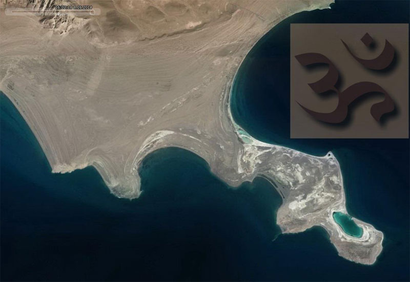
It is notable that form of a cape in the north coast of this lake coincides with the shape of Om reflecting the great sound of a first creation. Elements of Water and Earth produced this wonderful image in full detail.
 |
 |
| Blue Lagoon coincides with the Om’s top |
Chomolungma Mountain, the physical top of the world, became the important point of the expedition. The significant monastic complex and little-known cave, place of meditations of legendary Padmasabhava, are situated at the bottom of this mountain.
 |
Second part of the expedition programme was concerned with the continuing studies of the sacred Asian Kailas Mountain. During many centuries the Kailas Mountain has been the center of religious pilgrimage. Puranas and Jain literature say about great importance of this mountain for practices of various Indian religious traditions. Most of Sanskrit literary works about Kailas illustrate its role in religious terms; the mountain is mentioned as a place associated with Divinities and past Maharishis. Sanskrit literature also extols the spiritual beauty of the mountain. Tibetan literature of Bon religion and Buddhist sources adhere to the same concept of extoling Kailas as a place connected with a miracle and holiness.
Traditionally the ablutions were made in sacred lakes. First in the lake Rakshas Tal (Lhanagatso in Tibetan) which Tibetan Buddhists consider to be demoniac, and then in the sacred lake Manasarovar (Mapam yum tso). In 2010 on two of three islands of Rakshas Tal Lake the expedition of Sergey Balalaev discovered the pre-Buddhist archeological finds among the splendid natural landscape. Dokhangi Do Ser (Yellow Island) and Do Muk (Purple Island) are situated between two great mountains of Upper Tibet: Kailas (Tise) and Gurla Mandkhata (Takri Travo). According to the text sources these islands were a cultic center of Drablai Gyalmo – the most powerful female divinity of Shang Shung kingdom. She was the queen of all wrathful spirits and dual spirits of heaven and earth. Visit to her geomantic “heart” was a great blessing. So the ideas of demoniac character of this lake are relatively recent.
Unfortunately a part of the planned research near Kailas had to be moved to the next year because of the most significant restrictions over the last time ultimately connected with 2014 year – the year of Horse, distinctive for Kailas. Tibetans believe that the power of a sacred mountain is frequently multiplying and certainly strive to undertake pilgrimage at this time.
Nevertheless the expeditionists did the so called kora (trekking around the mountain) and made several radial exits within the ring of the external kora. The mountain trek Gevo La crossed by the southern traverse to Gyandrak and Serlung Monasteries was passed. Actually almost no one of the local residents knows about this route, though one of the famous Tibetan researchers of the last century, the Indian Svami Pranavanda mentioned about it. After the trek several valleys in the inner circuit of Kailas Mandala which are now visited only by local shepherds of yaks were explored. Several stone ring structures of various size oriented in the cardinal directions with ritual and probably astronomic significance were discovered.
 |
| Panorama from the Gevo Pass. Rakshas Tal Lake is at the horizon |
Along both sides of the trail where the pilgrims go through the Drolma La Pass there are two mountain formations which form is similar to the sacred Vedic symbol – Om (when watching it from the above.) Their sizes are about 2,8 km. It could be very clearly seen on the satellite imageries where the level in 5700 m is marked with a blue backgroud. These stone Oms seem to be the largest on our planet.
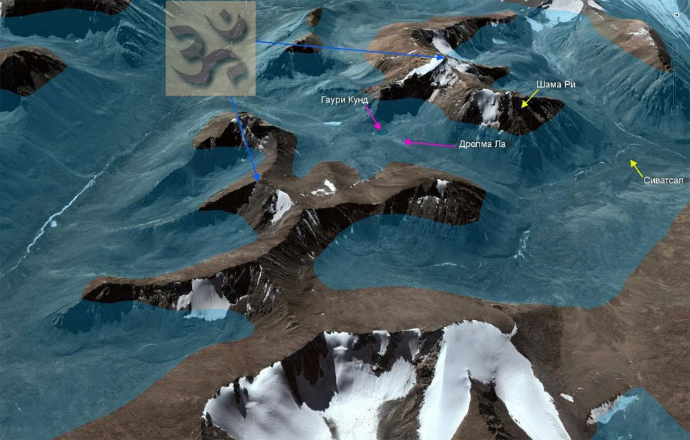 |
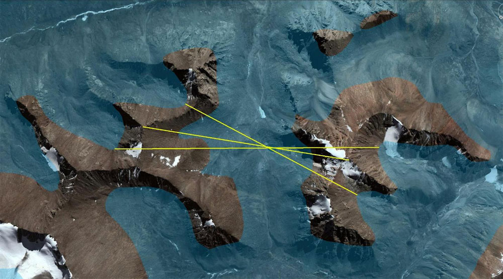
It’s extremely unusual that both Oms have a center of symmetry located in the sacred lake Gauri Kund. Of course these stone formations are not of human making but what surprises most of all is that they lay side by side and their main elements are symmetric! Thin material structure of this place is that original symbols appeared on the gross plane of our planet.
 |
Om mantra is a sacral sound which appears in the process of creation, emergence of the Universe and its destruction. It is one of the most ancient in Vedic culture. Om symbol is a symbol of infinity of spirit, the divine in the world and in the human being. Om syllable is the original sound creating the Universe – first manifestation of still not present Brahman, which gave birth to the perceptible Universe descended from the vibration produced by the Om sound. The influence of kora around Kailas has many levels and edges depending on the consciousness level of the pilgrim. One of the interpretation variants of how this place influences a human is as follows. Two huge and not human making stone Oms create special energy flows particularly affecting on the pilgrims passing between them – they transform their consciousness for achievement of the Integral state. One of the functions of this “device” is to erase a part of the pilgrim’s karma. However it works only with the sincere intention and bare heart. In the “new” life after kora one can be given a possibility to speed up the last life Karmic events, to extinguish them. Actually this is the effect of Karmic purification.
An Om-shaped mountain to the right known as Shama Ri is connected with lower realms. An Om-shaped mountain to the left is connected with highest realms. All together it offers the opportunity to form gross and subtle bodies of a man and establish links with one’s Highest aspects.
Central point of this “device” is the lake Gauri Kund where the expedition participants descended after meditations at the Drolma La Pass. Here one can take a few sips of water, sprinkle one’s head and wash one’s face. And one can merge with both Oms; feel the heavenly sound inside oneself…
 |
| Gauri Kund Lake |
During expedition a research of pre-Buddhist archeological monuments of Kailas Mountain was continued. Still not everyone knows that this sacred mountain was the basic center of early settlements in this region. The majestic Kailas Mountain was an asylum for a series of high-altitude temples and refuges built before the development of Bon and Buddhism in Tibet (collectively known as Lamaism). Practically nothing was known about the protohistorical (650-1000 AD) and prehistorical (100 BC-650 AD) settlements near Kailas Mountain prior to 2000 year when their existence was documented after a series of annual expeditions undertaken by the American explorer D.V.Bellezza. Ancient or pre-Buddhist structures of settlements on the Kailas Mountain differ from typical dwellings later. The one who went round this sacred mountain knows that four Buddhist monasteries are situated on the kora’s route. Two more monasteries are located on the route of so called inner circuit or inner kora. Archaic temples and constructions (before I millennium AD) are placed higher up the path of external kora in very remote areas. After I millennium these places seem to have only been temporarily used by the Buddhist hermits who needed the remote places for meditations.
As in most other districts of the vast mountain part of Tibetan, contours of habitual residences near Kailas Mountain were crucially shortened after I millennium AD. In ancient times temples and castles had been built at a height of 5400 m. However during Lamaism period (1000-1950 AD) huge buildings were not anymore constructed at a height above 4800 m. It is more likely that severe spiritual trials of pre-Buddhist local residents of these places and climatic deterioration are the principal causes of abandonment of settlements in higher-altitude geographical belt. In total more than 10 main places of ancient settlements existed at the foot of Kailas Mountain. Today all these places are left and only sometimes visited by accidental pilgrims or practitioners. Character of these early constructions points to the fact that in some cases pre-Buddhist inhabitants had more developed culture in comparison with the residents of Lamaism period. Anyhow the style of constructions used in ancient times was based on complex technologies of stone masonry which were out of use in Upper Tibet at the beginning of I millennium or so.
Photographic exhibition “Sacral Tibet. Great Lakes” and corresponding video film are going to be prepared following the materials of the expedition.